

1980s Miami-style map: make districts easy to recognize
Example preview
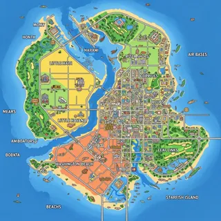
Build a playful top-down city map with pastel blocks, bold outlines and simple icons. Keep characters out and plan labels separately for readability.
Present a nostalgic fictional neighborhood through clear landmarks.
When to use this template
- A game-world map concept
- A retro neighborhood illustration
- A story-location overview
Build your first draft
Plan the scene
Choose a few districts and connecting roads.
Direct the image
Use distinct icons and flat color blocks without cast shadows.
Review the draft
Check road continuity and replace invented labels.
Try a complete example
A route to the roller rink
Retro top-down map: pastel waterfront blocks connect a diner, roller rink and palm-lined park by one clear road. Bold outlines, playful 1980s game-like look, simple icons, no characters or readable labels.
Three landmarks create an understandable route.
Before you publish
- This is not a verified historical map of Miami Shores.
- Generated street labels can be inaccurate.
Questions about this template
- Can I use it for real navigation?
- No; use verified mapping data for actual directions.
- Why avoid shadows?
- The source favors flat graphic clarity and icon readability.
- Is this a blank download?
- This is a creation starter in LlamaGen. Generate a draft, then review and refine it.